
A Data Collection Application for Geosciences Professionals
Abstract
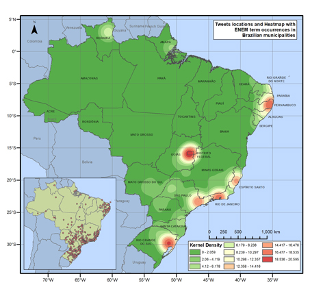
This article presents the process of elaborating a web platform that allows the georeferenced data collection in the Twitter API. This platform is intended for people who do not have computer language knowledge, including GIS users, since it simplifies the data collecting method from this social network. Moreover, it enables the realization of up to twelve types of queries that result in georeferenced data. As a case study, queries were made with the ENEM term and spatial analyzes were performed and they are presented in heat maps. The results show that there are no other applications with the same particularities of the present proposal and show possibilities to perform spatial analyzes through the data capture in social networks and GIS processing.
Keywords
Full Text:
PDFReferences
Alam, S., Cartledge, C. L. & Nelson, M. L. (2014) Support for Various HTTP Methods on the Web. Technical Report arXiv:1405.2330, 1(1), 1-16.
Apigee (2017). What is Apigee Edge? Retrieved September 20, 2017, from http://docs.apigee.com/api-services/content/what-apigee-edge
Bootstrap (2017). Ponto de partida. Retrieved September 21, 2017, from http://getbootstrap.com.br/getting-started
Borges, J. L. de C., Davis Junior, C. & Jankowski, P. (2016). A Study on the Use of Crowdsourcing Information for Urban Decision-Making. Revista Brasileira de Cartografia, 68(4), 695–703.
Borges, J. L. de C., Davis Junior, C. & Jankowski, P. (2015). Crowdsourced information from Tweets during the WorldCup in Brazil: A theme search. In: Proceedings of the International Conference on Changing Cities II: Spatial, Design, Landscape & Socio-economic Dimensions. pp. 1511 – 1519. Porto Heli: International Conference on Changing Cities II: Spatial, Design, Landscape & Socio-economic Dimensions
Burrough, P. A., Lloyd, C. & McDonnell, R. A. (2015) Principles of Geographical Information Systems. 3th Edition. New York: Oxford.
Camboim, S. P. & Sluter, C. R. (2013). Uso de ontologias para busca de dados geoespaciais: uma ferramenta semântica para a Infraestrutura Nacional de Dados Espaciais. Revista Brasileira de Cartografia, 65(6), 1127–1142.
Calafiore, A., Borges, J., Moura, A. C., & Boella, G. (2016). Integrating VGI system in a Participatory Design Framework. In Proceedings of 9th International Conference on Innovation in Urban and Regional Planning. 441–446. Torino: International Conference on Innovation in Urban and Regional Planning
Campagna, M. (2016). Social Media Geographic Information: Why social is special when it goes spatial? In: Capineri, C, Haklay, M, Huang, H, Antoniou, V, Kettunen, J, Ostermann, F and Purves, R. (Eds.) European Handbook of Crowdsourced Geographic Information, 45-54, London: Ubiquity Press.
Campagna, M., Massa, P. (2014). Social Media Geographic Information: Current Developments and Opportunities in Urban and Regional Planning. In Proceedings of 19th International Conference on Urban Planning, Regional Development and Information Society. 631–640.
Campagna, M., Floris, R., Massa, P., Girsheva, A., & Ivanov, K. (2015). The Role of Social Media Geographic Information (SMGI) in Spatial Planning. In: Geertman, S. et al. (Ed.) Planning Support Systems and Smart Cities. Cham: Springer International Publishing, 42-60.
Daiya, R., Khandekar, C., Parekh, R., Kellar, K. (2017). TweetSum: Automated News Summarization of Twitter Trends. International Journal of Computer Applications, 165(8), 5-8.
Diniz, A. M. A., Palhares, R. H., & Ribeiro, L. L. O impacto da realização da Copa das Confederações da FIFA de 2013 e da Copa do Mundo da FIFA de 2014 na criminalidade em Belo Horizonte. Revista Franco-Brasileira de Geografia, 32(1), 2-15.
Eclipse (2017). Eclipse IDE for Java EE Developers. Retrieved September 21, 2017, from https://eclipse.org/downloads/packages/eclipse-ide-java-ee-developers/oxygenr
Garcia-Molina, H., Joglekar, M., & Marcus, A., Paramensawaran, A., Verroios, V. (2016). Challenges in Data Crowdsourcing. IEEE Transactions on Knowledge and Data Engineering, 28(4), 901–911.
Hofer, B. (2017). Uses of online geoprocessing technology in analyses and case studies: a systematic analysis of literature. International Journal of Digital Earth, 8(11), 901–917
IBGE - Instituto Brasileiro de Geografia e Estatística (2017). Estimativas de População. Retrieved November 6, 2017, from https://www.ibge.gov.br/estatisticas-novoportal/sociais/populacao/9103-estimativas-de-populacao.html?&t=downloads
Inácio Júnior, V. R. (2007). Um Framework para Desenvolvimento de Interfaces Multimodais em Aplicações de Computação Ubíqua. (Master’s thesis) University of São Paulo, Brazil.
Jepson, B., Macdonald, B, & Stark, J. (2012). Building Android Apps with HTML, CSS, and JavaScript: Making Native Apps with Standards-Based Web Tools. 2nd Edition. California: O’Reilly Media Inc.
Kumar, V., Kumar, A., Sharma, A. K., & Singh, D. (2016). Implementation of MVC (Model-View-Controller) design architecture to develop web based Institutional repositories: A tool for Information and knowledge sharing. Indian Research Journal of Extension Education, 16 (3), 1–9.
Longley, P. A., Goodchild, M. F., Maguire, D. J., & Rhind, D. W. (2010). Geographic Information Systems and Science. Third Edition. Hoboken, NJ: Wiley.
Machado, J. (2017). Um método para análise e visualização de dados georreferenciados relacionados ao trânsito de veículos. (Master’s thesis). University of Vale do Rio dos Sinos, Brazil.
Macnamara, J. (2017). Evaluating Public Communication: Exploring New Models, Standards, and Best Practice. 1st Edition. New York: Routledge.
Macy, M. W., Mejova, Y., & Weber, I. (2015) Twitter: A Digital Socioscope. 1st Edition. New York: Cambridge University Press.
Marres, N., & Weltevrede, E. (2013). Scraping the Social? Issues in real-time social research. Journal of Cultural Economy, 6(3), 313–335.
Massa, P., & Campagna, M., (2016). Integrating Authoritative and Volunteered Geographic Information for spatial planning. In: Capineri, C, Haklay, M, Huang, H, Antoniou, V, Kettunen, J, Ostermann, F and Purves, R. (Eds.) European Handbook of Crowdsourced Geographic Information (pp. 401–418). London: Ubiquity Press.
Maven (2017). Welcome to Apache Maven. Retrieved September 21, 2017, from https://maven.apache.org/
Meireles, F., & Silva, D. (2015). Ciência Política na era do Big Data: automação na coleta de dados digitais. Revista Política Hoje, 24(2), 87–102.
Ogre (2017). ogr2ogr web client. Retrieved October 1, 2017, from http://ogre.adc4gis.com
Oracle (2017). Java™ EE at a Glance. Retrieved September 21, 2017, from http://www.oracle.com/technetwork/java/javaee/overview/index.html
Pizetta, D. C. (2014) Biblioteca, API e IDE para desenvolvimento de projetos de metodologias de Ressonância Magnética. (Master’s thesis). University of São Paulo, Brazil.
QGIS (2017). QGIS - The Leading Open Source Desktop GIS. Retrieved November 6, 2017, from http://www.qgis.org/pt_BR/site/about/index.html
Spring (2017). 22. Web MVC framework. Retrieved September 21, 2017, from https://docs.spring.io/spring/docs/current/spring-framework-reference/html/mvc.html
Twitter. Twitter Developer Documentation. Retrieved August 30, 2017, from https://dev.twitter.com/docs
Twitter4j. Main. Retrieved September 22, 2017, from http://twitter4j.org/en/index.html
Urru, M., & Vargiu, E. Exploiting web scraping in a collaborative filtering- based approach to web advertising. Artificial Intelligence Research, 2(1), 44–54.
Xavier-da-Silva, J. O que é geoprocessamento. Revista do Crea-RJ, 79(1), 42–44.
Refbacks
- There are currently no refbacks.
Copyright (c) 2018 Carla dos Santos Sá, Danilo Marques de Magalhães
DISEGNARECON
ISSN 1828 5961
Registration at L'Aquila Law Court no 3/15 on 29th June, 2015.
Indexed in SCOPUS. Diamond Open Access. All papers are subjected to double blind peer review system by qualified reviewers.
Journal founded by Roberto Mingucci