
Parametric Modeling as an Alternative Tool for Planning and Management of the Urban Landscape in Brazil – Case Study of Balneario Camboriu
Abstract
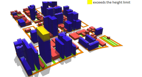
In Brazil, urban morphometric parameterization has become the main instrument of urban planning. Parametric Modeling of the Urban Landscape presents itself, therefore, as an important methodological tool to the landscape planning and construction. It emerges as a possibility to aggregate the different dimensions that compose the urban landscape which are capable of measurement. Moreover, it enables the planning of large areas according to specific aspects, which can be then developed into macro-solutions and projects at the local level. In this work, a dynamic cartography based on the Parametric Modeling of the Urban Landscape methodology is used to represent the landscape proposed by Balneario Camboriu’s urban laws.
Keywords
Full Text:
PDFReferences
Aguiar, T. (2017). Geodesign como teoria de planejamento: A verticalização de Balneario Camboriu (Master's thesis, UDESC, 2017). Florianópolis.
EMPORIS. (n.d.). EMPORIS. Retrieved April, 2018, from https://www.emporis.com/city/102068/balneario-camboriu-brazil
Kolbe, T. H., Nagel, C., & Stadler, A. (2009, September). CityGML–OGC Standard for Photogrammetry. In Photogrammetric week (Vol. 9, pp. 265-277).
Leach, N. (2009). Digital Cities. Architectural Design,79(4), 6-13. doi:10.1002/ad.911
Lee, D. (2016). Geodesign by integrating design and geospatial sciences. SPRINGER INTERNATIONAL PU.
Lee, D. J., Dias, E., Scholten H. J. (Eds.) 2014. Geodesign by Integrating Design and Geospatial Sciences. London, Springer.
Leite, M. (1994). Destruição ou desconstrução? Questões da paisagem e tendências de regionalização. Hucitec.
Moura, A. (2014). Geoprocessamento na gestão e planejamento urbano. Rio de Janeiro: Interciência.
Moura, A. C. (2012). Learning topics in urban planning at UFMG:Geoprocessing to support analysis, planning and proposal of the urban landscape at neighborhood scale. Paranoá: Cadernos De Arquitetura E Urbanismo,(7). doi:10.18830/issn.1679-0944.n7.2012.12313
Moura, A. C. (2015). Geodesign in Parametric Modeling of urban landscape. Cartography and Geographic Information Science,42(4), 323-332. doi:10.1080/15230406.2015.1053527
Programa das Nações Unidas para o Desenvolvimento. (2013). Atlas do Desenvolvimento Humano no Brasil 2013. Retrieved from http://www.atlasbrasil.org.br/2013/
Rafiee, A., Kroese, K., Anders, N., Paardekooper, M., Spectjens N. J., Scholten, B. & Lindie, M. 3D geodesign approach for bottom-up urban planning. Proceeedings of Geodesign Europe 2016, Esri.
Schumacher, P. (2009). Parametricism: A new global style for architecture and urban design. Architectural Design, 79(4), 14-23.
Vamos LATAM. (n.d.). Retrieved December, 2017, fromhttps://issuu.com/spafax/docs/vamos_dic_2017_web
Zyngier, C. (2016). Paisagens urbanas possíveis: Códigos compartilhados através dos Sistemas de Suporte ao Planejamento e do Geodesign (Master's thesis, UFMG, 2016). Belo Horizonte: UFMG.
Refbacks
- There are currently no refbacks.
Copyright (c) 2018 Marina Magalhães de Castro, Ana Clara Mourão Moura, Renata Herculano Nogueira, Tatiana de Aguiar, Francisco Henrique de Oliveira
DISEGNARECON
ISSN 1828 5961
Registration at L'Aquila Law Court no 3/15 on 29th June, 2015.
Indexed in SCOPUS. Diamond Open Access. All papers are subjected to double blind peer review process by qualified reviewers.
Journal founded by Roberto Mingucci