
A research initiative on the use of Geodesign for public health in South America: An innovative approach
Abstract
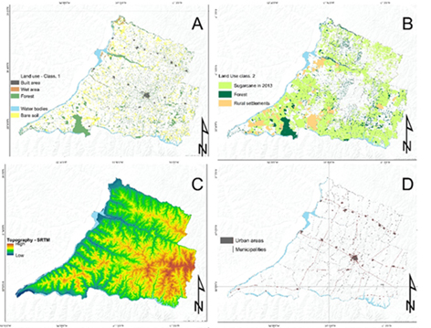
This study aims to explore and evaluate, with the support of Geodesign, a model for visceral leishmaniasis (VL) in the Pontal do Paranapanema region of Brazil. We created a framework through assessment analysis, with the layers consisting of entomological, VL reports, socioeconomic, and environmental variables. Data analysis was crafted using a geographic information system (GIS) to evaluate 53 municipalities. Lutzomyia longipalpis presence was associated with VL and both displayed southeastern expansion as well as an association with land surface temperature in the hottest and driest areas, modified vegetation, and roads. This innovative Geodesign approach unites technology and community stakeholders to collectively.
Keywords
Full Text:
PDFReferences
Alessi, C. Á. C., Galati, E. A. B., Alves, J. R., & Corbett, C. E. P. (2009). American cutaneous leishmaniasis in the Pontal of Paranapanema - SP, Brazil: Ecological and entomological aspects. Revista Do Instituto de Medicina Tropical de Sao Paulo, 51(5), 277–282. https://doi.org/10.1590/S0036-46652009000500008
Anderson, R. P., Lew, D., & Peterson, A. T. (2003). Evaluating predictive models of species’ distributions: criteria for selecting optimal models. Ecological Modelling, 162(3), 211–232. https://doi.org/10.1016/S0304-3800(02)00349-6
Barbosa, D. S., Belo, V. S., Rangel, M. E. S., & Werneck, G. L. (2014). Spatial analysis for identification of priority areas for surveillance and control in a visceral leishmaniasis endemic area in Brazil. Acta Tropica, 131(1), 56–62. https://doi.org/10.1016/j.actatropica.2013.12.002
Basra, K., Fabian, M. P., Holberger, R. R., French, R., & Levy, J. I. (2017). Community-Engaged Modeling of Geographic and Demographic Patterns of Multiple Public Health Risk Factors. Journal of Environmental Research and Public Health, 14(730). https://doi.org/10.3390/ijerph14070730
Bhunia, G. S., Dikhit, M. R., Kesari, S., Sahoo, G. C., & Das, P. (2011). Role of remote sensing, geographic bioinformatics system and bioinformatics in kala-azar epidemiology. Journal of Biomedical Research, 25(6), 373–384. https://doi.org/10.1016/S1674-8301(11)60050-X
Bhunia, G. S., Kesari, S., Jeyaram, A., Kumar, V., & Das, P. (2010). Influence of topography on the endemicity of Kala-azar: A study based on remote sensing and geographical information system. Geospatial Health, 4(2), 155–165. https://doi.org/10.4081/gh.2010.197
Brooker, S., & Utzinger, J. (2007). Integrated disease mapping in a polyparasitic world. Geospatial Health, 1(2), 141–146. https://doi.org/10.4081/gh.2007.262
Camargo-Neves, V. L. F. de, Katz, G., Rodas, L. A. C., Poletto, D. W., Lage, L. C., Spínola, R. M. F., & Cruz, O. G. (2001). Utilização de ferramentas de análise espacial na vigilância epidemiológica de leishmaniose visceral americana - Araçatuba, São Paulo, Brasil, 1998-1999. Cadernos de Saúde Pública, 17(5), 1263–1267. https://doi.org/10.1590/S0102-311X2001000500026
Cardim, M. F. M., Rodas, L. A. C., Dibo, M. R., Guirado, M. M., Oliveira, A. M., & Chiaravalloti-Neto, F. (2013). Introduction and expansion of human American visceral leishmaniasis in the state of Sao Paulo, Brazil, 1999-2011. Revista de Saude Publica, 47(4), 1–9. https://doi.org/10.1590/S0034-8910.2013047004454
Coura-Vital, W., Marques, M. J., Veloso, V. M., Roatt, B. M., de Oliveira Aguiar-Soares, R. D., Reis, L. E. S., & Carneiro, M. (2011). Prevalence and factors associated with Leishmania infantum infection of dogs from an urban area of Brazil as identified by molecular methods. PLoS Neglected Tropical Diseases, 5(8), e1291. https://doi.org/10.1371/journal.pntd.0001291
Cross, E. R., Newcomb, W. W., & Compton Tucker, D. J. (1996). Use of Weather Data and Remote Sensing To Predict the Geographic and Seasonal Distribution of Phlebotomus Papatas! in Southwest Asia. Am. J. Trop. Med. Hvg, 54(5), 530–536.
D’Andrea, L. A. Z., da Silva Fonseca, E., Prestes-Carneiro, L. E., Guimarães, R. B., Yamashita, R. C., Soares, C. N., & Tolezano, J. E. (2015). The shadows of a ghost: a survey of canine leishmaniasis in Presidente Prudente and its spatial dispersion in the western region of São Paulo state, an emerging focus of visceral leishmaniasis in Brazil. BMC Veterinary Research. https://doi.org/10.1186/s12917-015-0583-6
Davenhall, B. (2010). Helping Shape Global Health. Esri Health and Human Services, 1.
Ervin, S. (2012). A System for GeoDesign. Peer Reviewed Proceedings Digital Landscape Architecture 2012 at Anhalt University of Applied Sciences, 145-.
Ervin, S. M. (2012). Geodesign Futures – Nearly 50 Predictions, 22–30.
Fonseca ES, D’Andrea LAZ, Taniguchi HH, Hiramoto R.M., & Tolezano JE, G. R. (2014). Spatial epidemiology of American cutaneous leishmaniasis in a municipality of west São Paulo State, Brazil. Journal of Vector Borne Diseases, 51, 271–275.
Goodchild, M. F., & Ph, D. (2010). Towards Geodesign : Repurposing Cartography and GIS? Cartographic Perspectives, (66), 55–69.
Harhay, M. O., Olliaro, P. L., Costa, D. L., & Costa, C. H. N. (2011). Urban parasitology: Visceral leishmaniasis in Brazil. Trends in Parasitology, 27(9), 403–409. https://doi.org/10.1016/j.pt.2011.04.001
Hay, S. I., Battle, K. E., Pigott, D. M., Smith, D. L., Moyes, C. L., Bhatt, S. & Gething, P. W. (2013). Global mapping of infectious disease Global mapping of infectious disease. Phil Trans R Soc Lond B, 368(February).
Hinckson, E., Schneider, M., Winter, S. J., Stone, E., Puhan, M., Stathi, A., & King, A. C. (2017). Citizen science applied to building healthier community environments : advancing the field through shared construct and measurement development, 1–13. https://doi.org/10.1186/s12966-017-0588-6
Huang, G., & Zhou, N. (2016). Geodesign in Developing Countries: The example of the Master Plan for Wulingyuan National Scenic Area, China. Landscape and Urban Planning, 156, 81–91. https://doi.org/10.1016/j.landurbplan.2016.05.014
Hulse, D., Branscomb, A., Enright, C., Johnson, B., Evers, C., Bolte, J., & Ager, A. (2016). Anticipating surprise: Using agent-based alternative futures simulation modeling to identify and map surprising fires in the Willamette Valley, Oregon USA. Landscape and Urban Planning, 156, 26–43. https://doi.org/10.1016/j.landurbplan.2016.05.012
IBGE. (2011). Indicadores sociais municipais. Estudos e pesquisas: informação demográfica e socioeconômica. (Vol. 28). https://doi.org/0101-4234
Martinelli, M. (2009). O Relevo do estado de São Paulo. Confins Revue, 7(7), 1–19.
Martinelli, M. (2010a). Clima do estado de São Paulo. Confins Revue, 8(8), 1–16. Retrieved from http://www.imp.seade.gov.br
Martinelli, M. (2010b). Estado de São Paulo : aspectos da natureza. Confins Revue, 9(9), 1–15.
Meyers, D. J., Ozonoff, A., Baruwal, A., Pande, S., & Harsha, A. (2016). Combining Healthcare-Based and Participatory Approaches to Surveillance : Trends in Diarrheal and Respiratory Conditions Collected by a Mobile Phone System by Community Health Workers in Rural Nepal. PLoS ONE, (December 2013), 1–13. https://doi.org/10.1371/journal.pone.0152738
Miller, W. R. (2012). Introducing Geodesign : The Concept Director of GeoDesign Services. ESRI, 36.
Murray, H. W., Berman, J. D., Davies, C. R., Saravia, N. G., Annajar, B. B., Hanafi, H. A., & Vounatsou, P. (2012). Ecological niche model of Phlebotomus alexandri and P. papatasi (Diptera: Psychodidae) in the Middle East. PLoS Neglected Tropical Diseases, 9(1), 2. https://doi.org/10.1186/1476-072X-9-2
Nyerges, T., Ballal, H., Steinitz, C., Canfield, T., Roderick, M., Ritzman, J., & Thanatemaneerat, W. (2016). Geodesign dynamics for sustainable urban watershed development. Sustainable Cities and Society, 25, 13–24. https://doi.org/10.1016/j.scs.2016.04.016
PAHO/WHO. (2008). Update of American Trypanosomiasis and Leishmaniasis Control and Research: Final Report, 1-176.
Peterson, A. T. (2006). Ecologic niche modeling and spatial patterns of disease transmission. Emerging Infectious Diseases, 12(12), 1822–1826. https://doi.org/10.3201/eid1212.060373
Peterson, A. T., Campbell, L. P., Moo-llanes, D. A., Travi, B., González, C., Cristina, M., & Shaw, J. J. (2017). Influences of climate change on the potential distribution of Lutzomyia longipalpis sensu lato ( Psychodidae : Phlebotominae ). International Journal for Parasitology. https://doi.org/10.1016/j.ijpara.2017.04.007
Phillips, S. J., Anderson, R. P., & Schapire, R. E. (2006). Maximum entropy modeling of species geographic distributions. Ecological Modelling, 190(3-4), 231–259. https://doi.org/10.1016/j.ecolmodel.2005.03.026
Phillips, S. J., Avenue, P., & Park, F. (1997). A Maximum Entropy Approach to Species Distribution Modeling.
Pratt, B. M., Are, W., & Communities, H. (2011). Place and Health: Designing communities that promote well-being. ArcUser, 14–18.
São Paulo. (2006). Manual de Vigilância e Controle da Leishmaniose Visceral Americana do Estado de São Paulo. Secretaria de Estado Da Saúde, 161.
Steinitz, C. (2012). A framework for geodesign: changing geography by design. Esri Press.
Turrell, G., Hewitt, B., Haynes, M., Nathan, A., & Giles-corti, B. (2014). Change in walking for transport : a longitudinal study of the influence of neighbourhood disadvantage and individual-level socioeconomic position in mid-aged adults. https://doi.org/10.1186/s12966-014-0151-7
Werneck, G. L. (2010). Geographic spread of visceral leishmaniasis in Brazil. Cadernos de Saúde Pública, 26(4), 644–645. https://doi.org/10.1590/S0102-311X2010000400001
Wilson, M. W. (2015). Landscape and Urban Planning On the criticality of mapping practices : Geodesign as critical GIS? Landscape and Urban Planning, 142, 226–234. https://doi.org/10.1016/j.landurbplan.2013.12.017
Wissen Hayek, U., von Wirth, T., Neuenschwander, N., & Grêt-Regamey, A. (2016). Organizing and facilitating Geodesign processes: Integrating tools into collaborative design processes for urban transformation. Landscape and Urban Planning, 156(156), 59–70. https://doi.org/10.1016/j.landurbplan.2016.05.015
Refbacks
- There are currently no refbacks.
Copyright (c) 2018 Elivelton Da Silva Fonseca, Ryan Harry Avery, Vladimir Diniz Vieira Ramos
DISEGNARECON
ISSN 1828 5961
Registration at L'Aquila Law Court no 3/15 on 29th June, 2015.
Indexed in SCOPUS. Diamond Open Access. All papers are subjected to double blind peer review process by qualified reviewers.
Journal founded by Roberto Mingucci