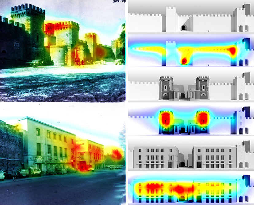
Knowledge of urban space through saliency maps and space syntax tools. Experimentation on historic center of Rieti
Abstract
The 60s of the last century were characterized by a great cultural ferment on the theme of urban space and its transformations resulting from conurbation. The political, social, economic, and environmental implications of this phenomenon were notable, to which we attempted to give both a cultural and scientific response. An important aspect concerned the need to govern urban and territorial transformations, guaranteeing the quality of urban space but, at the same time, safeguarding the memory of the historic centers which, precisely in those years, were undergoing the strong pressure of conurbation dynamics. One of the key studies is undoubtedly The Image of the City by Kevin Lynch from 1960 in which the author analyzes the role of environmental images in the perception of the city and its space. These studies are followed by other equally famous contributions (Cullen, 1961; Rossi, 1966; Norberg-Schulz, 1979) which, by exploring the mechanisms of the individual’s perception of the environment, have given rise to a vast literature in the international field. Experiments in which the authors deal with urban reality, with its experience and the history of the traditional city in an attempt to develop codes to interpret and evaluate not only the characteristics of the physical city, but to look at urban spaces as spaces of relation.
Subsequent studies were started from the theories developed by Lynch and Cullen which define different methodologies for analyzing the urban landscape, to support the planning of new interventions and the transformation of pre-existing urban areas. Between the 70s and 80s, a group of researchers from University College London laid the foundations of what is now defined as spatial syntax, also known as configurational theory, applied to studies and analyses of urban space.
DOI: https://doi.org/10.20365/disegnarecon.31.2023.7
Keywords
Full Text:
PDFReferences
Benedikt, M. L. (1979). To take hold of space: isovists and isovist fields. Environment and Planning B, 6(1), 47-65.
Conroy, R. (2001). Spatial navigation in immersive virtual environments, University of London, 127-132, 153-160.
Conroy Dalton, R. (2003). The secret is to follow your nose. Route Path Selection and Angularity, Environment and behavior, 35(1), 107-131.
Cooper, J., Oskrochi R. (2008). Fractal analysis of street vistas: a potential tool for assessing levels of visual variety in everyday street scenes, in Environment and Planning B: Planning and Design, 35, 349-363.
Cooper, J., Oskrochi R., Watkinson, D. (2010). Fractal analysis and perception of visual quality in everyday street vistas, Environment and Planning B: Planning and Design, 37, 808-822.
Cooper, J., Su M. L., Oskrochi R. (2013). The influence of fractal dimension and vegetation on the perceptions of streetscape quality in Taipei: with comparative comments made in relation to two British case studies, Environment and Planning B: Planning and Design, 40, 43-62.
Cullen, G. (1961). Townscape, Architectural Press, New York.
Cutini, V. (2010). La rivincita dello spazio urbano. L’approccio configurazionale allo studio e all’analisi dei centri abitati, Plus, Pisa.
Dalton, N. S., Dalton, R. C., Marsala, P., Peverett, I., Clinch, S. (2015). Three dimensional Isovists for the Study of Public Displays, 10th Space Syntax Symposium, London.
Franz, G., Wiener, J. M. (2008). From space syntax to space semantics: a behaviorally and perceptually oriented methodology for the efficient description of the geometry and topology of environments. Environment and Planning B Planning and Design, 35(4), 574-592.
Harel, J., Koch, C., Perona, P. (2006). Graph-Based Visual Saliency, California Institute of Technology.
Hillier, B., Hanson, J. (1984). The Social Logic of Space, Cambridge University Press, London.
Itti, L., Kock, C. (2001). Computational modeling of visual attention, Nature Reviews Neuroscience, 2, 194-203.
Koch, C., Ullman, S. (1985). Shift in selective visual attention: Towards the underlying natural circuitry, Human Neurobiol, 4, 219-227.
Leduc, T., Miguet, F., Tourre, V. (2017). Motion Perspectives Integration in the Qualification of the Urban Spaces: Towards a 2D- and a 3D-Enrichment of the S-Partition Method. Urban Design and Representation, 69-82.
Leduc, T., Kontovourkis, O. (2012) Towards a mixed approach combining visibility and mobility studies to analyze the Eleftheria Square, Nicosia (CY), COST Action TU0801 - 3D Issues in Urban and Environmental Systems, Società Editrice Esculapio, 67-77.
Lynch, K. (1960). L’immagine della città, Marsilio, Venezia.
Nasar, J. L. (1997). The evaluative image of city, Londra.
Nijhuis Ronvan, S., Van Lammeren, R., Van der Hoeven, F. (2011). Exploring the visual landscape. Advances in Physiognomic Landscape Research in the Netherlands, IOS Press, Olanda.
Norberg-Shulz, C. (1979). Genius Loci. Paesaggio Ambiente Architettura, Electa, Milano.
Paris, L., Rossi, M. L. (2023). La conoscenza delle trasformazioni urbane per la salvaguardia e valorizzazione dei centri storici. Il caso di Porta Cintia a Rieti. Disegnare Idee Immagini, 64, Gangemi Editore, 50-61.
Rossi, A. (1966). L’Architettura della città, Città Studi Edizioni, Milano.
Stöger, H. (2011). Rethinking Ostia: a spatial enquiry into the urban society of Rome’s imperial port-town, Doctoral Thesis in Archaeological Studies Leiden University, 24, Leiden University Press, Amsterdam.
Turner, A., Doxa, M., O’Sullivan, D., Penn, A. (2001). From Isovist to Visibility Graphs: A Methodology for the Analysis of Architectural Space. Enviromental and Planning B Planning and Design, 28(1), 103-121.
Van Nes, A., Yamu, C. (2021). Introduction to Space Syntax in Urban Studies, Springer, Cham, Switzerland.
Verdoscia, C., De Mattia, F. P., Maiorano, C., Di Puppo, M., Tavolare, R. (2015). Il modello percettivo dell’immagine urbana, Disegno&Città. Cultura Scienza Arte Informazione, 863-870.
Weitkamp, G. (2010). Capturing the view: a GIS based procedure to assess perceived landscape openness. Wageningen University, The Nederland.
Refbacks
- There are currently no refbacks.
Copyright (c) 2023 Leonardo Paris, Maria Laura Rossi, Angela Moschetti
DISEGNARECON
ISSN 1828 5961
Registration at L'Aquila Law Court no 3/15 on 29th June, 2015.
Indexed in SCOPUS. Diamond Open Access. All papers are subjected to double blind peer review process by qualified reviewers.
Journal founded by Roberto Mingucci
